


GeoCalc (Coordinate calculator)
وصف لـGeoCalc (Coordinate calculator)
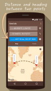
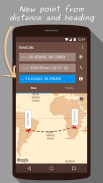
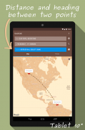
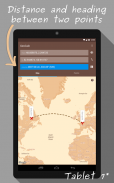
GeoCalc calculates geographical coordinates given a start point, distance and heading, or, calculates the distance and heading between two points. The calculated coordinates can be set as the initial coordinates, allowing fast consecutive calculations.
GaoCalc may be used for roadbook off-road racing, hiking, sailing, orienteering, geocaching, questing, treasure hunting, hobby flying, for education, for fun, or anyone needing to calculate bearings and distances between coordinates.
Calculations are performed using an accurate ellipsoidal model of the Earth's surface.
FEATURES:
- Calculate coordinates of a point, given a start point, heading and distance
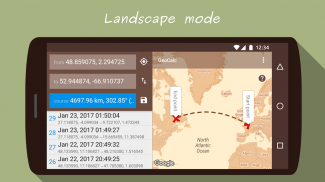
- Calculate heading and distance between two points
- Show points on map
- Use coordinates from current GPS position
- Coordinates as decimals or DMS
- Metric, imperial or nautical units
- Save all calculated points
- Share saved points
GeoCalc تحسب إحداثيات جغرافية معينة نقطة البداية، وبعد المسافة والعنوان، أو بحساب المسافة والتوجه بين نقطتين. يمكن تعيين إحداثيات محسوبة على الإحداثيات الأولية، مما يسمح للحسابات سريعة متتالية.
GaoCalc يمكن استخدامها لمرشد الطرق الوعرة سباق، المشي لمسافات طويلة، والإبحار، التزلج، غيوكاشينغ، questing والصيد الكنز، هواية الطيران، للتعليم، للمتعة، أو أي شخص يحتاجون لحساب محامل والمسافات بين الإحداثيات.
يتم تنفيذ العمليات الحسابية باستخدام نموذج بيضاوي دقيقة من سطح الأرض.
ميزات:
- حساب إحداثيات نقطة، ونظرا لنقطة البداية، تتجه والمسافة
- احسب العنوان والمسافة بين نقطتين
- عرض نقاط على الخريطة
- استخدام الإحداثيات من الموقف الحالي لتحديد المواقع
- ينسق كما عشرية أو DMS
- متري، وحدات إمبراطورية أو بحري
- حفظ جميع النقاط المحتسبة
- حصة نقطة حفظ
GeoCalc (Coordinate calculator) - إصدار 2.6.1
(09-06-2023)GeoCalc (Coordinate calculator) - معلومات APK
نُسخة APK: 2.6.1الحزمة: com.bitwize10.geocalcآخر إصدار من GeoCalc (Coordinate calculator)
نُسخ أخرى


تطبيقات من الفئة نفسها


